 Loading... Please wait...
-
Call us at 978-392-1461
- Gift Certificates
- My Account

- Home
- Classroom Posters
- What is a Map? Educational School Map Chart 12x18 US Made Poster
Categories
Related Products

What is a Map? Educational School Map Chart 12x18 US Made Poster

Hover over image to zoom
)
Product Description
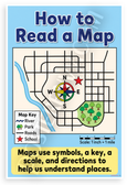
This 12x18 inch poster is printed on premium, durable paper. Proudly Made in the USA by PosterEnvy. The perfect size for any room. PosterEnvy is a family owned business, delivering top-notch posters around the world for over 20 years. Our posters are designed to last — they won't fade or pucker for years of enjoyment. Every poster features crisp, vivid artwork. We are a solar powered company. This colorful educational poster explains what a map is with a simple school map next to the real place, using cartoon illustrations of buildings, playground, lawn, and symbols. Key points include: A map is a drawing of a place; Maps help us find where things are; Maps use symbols and colors; Maps help us understand our world!
- Premium Print: This PosterEnvy 12x18 inch poster is printed on Durable, Heavy Duty Paper, Designed to last many years. Features What is a Map? educational chart with school map illustration, symbols, colors for kids learning geography basics
- Proudly Made in the USA: PosterEnvy is a Family owned business, delivering top-notch posters around the world for over 20 years. Ideal for elementary classroom decor, homeschool geography, 2nd grade map skills
- Solar Powered Production: All our posters are designed and printed using solar energy, with crisp vivid artwork. Bright cartoon style shows map vs real school, playground symbols, sunny sky for engaging kids education
- Engaging Map Lesson: Vibrant cartoon design contrasts simple school map with real buildings, playground, lawn using colors and symbols. Creates fun learning mood, perfect for elementary classrooms, homeschool walls, kids study areas
- Perfect Gift Idea: Great for young learners, teachers, parents teaching geography basics. Ideal for birthdays, back to school, homeschool setups, elementary classrooms; search terms: kids map poster, what is a map chart
Find Similar Products by Category
Product Reviews
You Recently Viewed...
Quick Links
What's News
Follow us on

Copyright 2026 PosterEnvy.com. All Rights Reserved.
Sitemap |
BigCommerce Premium Themes by PSDCenter